
The pilot project is owned by:
Aim of the pilot project
BaneNOR is responsible for the construction, operation and maintenance of the national railway infrastructure. The railway network goes through changing topographical, geological and climatic conditions, where flood and landslide-related events occasionally occur and cause traffic disruption. Such incidents also carry a significant risk of personal injury and material loss. Water-related incidents include a wide range of types, from regular flooding, "washing away" of the railroad body because of poor culvert capacity, collapse of railway fillings, landslides, slush avalanches, rockfalls, combinations of events etc.
The aim of the pilot project is to test the possibility of warning of increased danger of landslides and collapse of railway fillings based on instrumentation and physical modeling of the stability conditions for slopes or landfills. This is done for two locations:
Bodø station, where simplified instrumentation is planned in the form of pore pressure measurements, precipitation and possibly soil moisture and temperature in selected cross sections of the long slope running parallel to the rail line on the final leg into Bodø station. This slope has experienced several slides over the years.
The section IC Venjar-Eidsvoll, where an existing monitoring system is in place but not actively measured, will be revitalized to continue measurements. The area instrumented is the slope up to Wergelandslunden at Eidsvoll church.
Participants

Innovation potential
Large parts of existing rail networks have challenges related to water-related landslides, as well as sections of the existing railway fillings which are believed to have poor stability. Potential landslide events at these locations are unlikely to be prevented in the short term – solving these issues will require time and significant costs. However, typical "hot spots" may be managed by improving drainage and other drainage measures, or by implementing warning systems.
The innovation potential of the pilot project lies in:
Linking weather data, topographic, hydrological and geological data with local measurements to improve understanding of hydrological response in natural slopes and rail fillings.
Use numerical models for better assessment of real landslide hazard for exposed stretches. This includes links to the development of numerical methods and notification.
Testing of a data-based alert based on web-casting of data with automated data management and stability calculation. Initially, this will be based on simple theoretical stability models for slope stability, but where hydrological parameters are included (measured pore pressure and soil moisture in the soil).
Testing of innovative drainage measures to reduce pore pressure build-up along stretches where measurements show increased pore pressure and soil moisture due to rainfall.
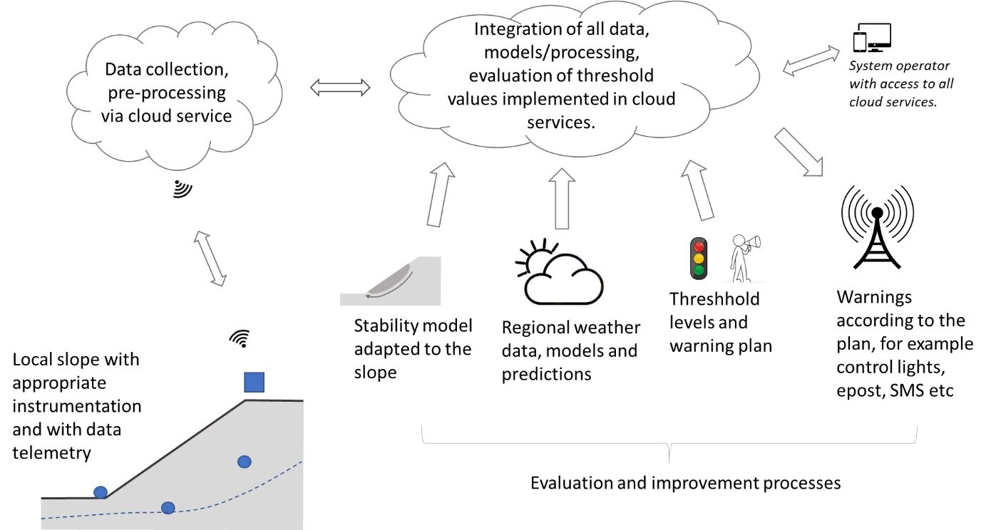
Landslide alert based on web casting of in situ data with automated stability calculation
Lessons learnt
Description of the pilot project in Norwegian
A monitored unsaturated slope in Norway: Eidsvoll case study. Klima 2050 Report 35. Oslo 2022. ISBN: 978-82-536-1760-2
Nye instrumenter installert i Klima 2050 piloten på Eidsvoll